To determine the designation of your property, you can use our interactive Official Plan map.
Official Plan
An Official Plan is a document that sets out the land use policy directions for long-term growth and development in a municipality.
New Official Plan
The Township of Wilmot is preparing a new Official Plan to replace the current Township Official Plan and Regional Official Plan. For more information and to become involved in this process, please visit our Engage Wilmot page.
Current Official Plan
The Region of Waterloo approved updates to the Township of Wilmot Official Plan which came into effect on April 19, 2019.
As of January 1, 2025, the Township of Wilmot is responsible for the Region of Waterloo Official Plan as it applies to land use in the Township of Wilmot.
For the complete Township of Wilmot Official Plan, you can view the document and maps below which incorporate further amendments up to May 1, 2024.
Official Plan Documents and Maps
- Map 1: Context Map
- Map 2.1: Planned Township Structure
- Map 2.2: Designated Greenfield Areas
- Map 3: Environmentally Constrained
- Map 4.1: Baden Urban Area
- Map 4.2: New Hamburg Urban Area
- Map 5.1: Foxboro Green
- Map 5.2: Haysville
- Map 5.3: Lisbon
- Map 5.4: Luxemburg
- Map 5.5: Mannheim
- Map 5.6: New Dundee
- Map 5.7: Petersburg
- Map 5.8: Philipsburg
- Map 5.9: Shingletown
- Map 5.10: St. Agatha
- Map 5.11: Sunfish Lake
- Map 5.12: Wilmot Centre
- Map 6.1: Transportation
- Map 6.2: Cycling Routes
- Map 7: The Greenlands Network
- Map 8: Source Water Protection Areas
- Map 9: Mineral Aggregate Resource Areas
- Map 10: The Countryside
Looking to confirm a property's Official Plan designation? Use our interactive Official Plan Map.
Official Plan Amendments
Changes to the Official Plan are sometimes required to reflect changes to Provincial policy and to allow new development or redevelopment proposals. Opportunities for public review and input are provided through the Official Plan amendment process.
To learn more about applying to amend the Official Plan, please visit the Start a Development Application page.
Growth Management
Review the information below for a 20 year history of growth management in Wilmot Township from the 2003 Official Plan through Regional Plan Amendment 6 and Bill 162 in 2024.
You can also view a map identifying approved, upcoming, and planned developments within the growth area between Baden and New Hamburg.
- July 2002: Township of Wilmot Response to "Planning Our Future: A Smart Growth Initiative by the Region of Waterloo"
- March 2003: Township of Wilmot Response to "Planning Our Future - Phase II: Options for a Regional Growth Management Study"
- June 2003: Township of Wilmot Response to "Planning Our Future - Recommended Growth Management Study"
- July 2003: New Township Official Plan
- March 2009: Response to First Draft of Regional Official Plan - 2019"
- July 2009: Region of Waterloo Official Plan
- June 2017: Proposed Official Plan Amendments - Conformity Review and Rationalization
- December 2017: Township Official Plan Amendment Number 9
- May 2022: Region of Waterloo Official Plan Review - Land Needs Assessment
- August 2022: Region of Waterloo Adoption of ROPA 6
- May 2023: Proposed New Provincial Planning Statement (PPS) 2023
- June 2023: Minister's Decision on ROPA 6
- November 2023: Response to MMAH regarding Official Plan Decisions
- March 2024: Bill 162, Get it Done Act, 2024: Comments on changes to the Official Plan Adjustments Act
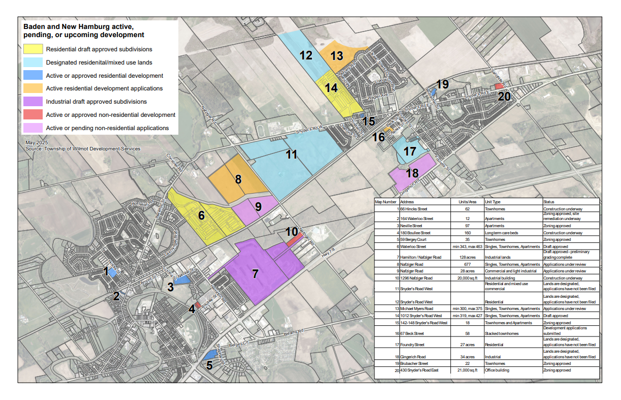 Development overview map
Contact
Planning Division
60 Snyder's Road West
Baden, ON N3A 1A1
T: 519-634-8444
Toll Free: 1-800-469-5576
TTY: 1-866-620-2994
F: 519-634-5522
Email
Sign up for news alerts
Stay up to date on Township activities, events, programs and operations by subscribing to our news alerts.